|
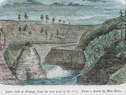
Almost twenty years before William Pryor Letchworth appeared on the scene, the Portage Gorge attracted the attention of the famous 19th century geologist, James Hall. Known by some as the "Father of Modern Geology", Hall spent several years studying the rock strata in the cliffs of the Portage gorge. His findings were were published by New York State in 1843. We recently heard from Mr. Jim Pomeroy of Caneadea NY who was kind enough to send us material he found in that 1843 report entitled Geology of New York, Part IV (Survey of the Fourth Geological District) by James Hall. As Jim writes, "The Fourth Geological District included much or most of the Finger Lakes area and all of Western New York. A copy of this report/book can be found in the Genesee (Valley) Room at the SUNY Geneseo Library. James Hall became a highly acclaimed geologist at a time when geology was in its infancy and when many of its modern principles were just being formulated. For a brief biography of Mr. Hall and some perspective on his contributions, you can use this link. In preparing his report Mr. Hall made a number of trips to Western New York. Chapter 18 of the report is concerned with the geology of the Genesee River in what we know today as Letchworth State Park. Mrs. Hall apparently accompanied her husband on one or more of these trips. She was an excellent illustrator and she created a number of drawings appearing in the report. One of those drawings, entitled "the Lower Falls" , appears on page 368." You will find below two hand colored drawings from the report and some of the text relating to the Lower Falls. We thank Jim Pomeroy for sharing his research with us! For later photographs of the Portage Falls see our Historical Photo Album |
|
This sketch shows table rock (middle right) and Sugar Loaf (middle left) Between them is what was the "Lower" Falls when the Halls visit the area. The water has, at this time period, already cut the famous flume and was no longer flowing over Table rock as it had within the "memory of the oldest observer". Compare this image with an early 20th century view. |
|
Excerpts from Geology of New York, Part
IV (Survey of the Fourth Geological District) by James
Hall pp. 368-371 (comments in parenthesis by Jim Pomeroy) The sketch represents the lower falls of the Genesee at Portage. The bed of the stream is bounded on either side by cliffs three hundred feet high. Upon the left bank (he should have said "right" bank with regard to the drawing since the drawing is looking upstream) is a table of rock, which was formerly the river bed; and upon the right bank (left bank in the drawing) is a conical island of rock (Cathedral Rock), between which and the table on the other side, the stream now flows. Within the memory of the oldest observers, the river flowed almost wholly over this table rock, and the isolated mass (Cathedral Rock) was joined with the right bank of the river. (the) depression (between Cathedral Rock on the left and Table Rock on the right in the drawing) increased in depth by the wearing action of the water and the effects of freezing, so that long since, the great body of water has flowed through this recent channel. During freshets (floods), and at the breaking up of the ice in the spring, the narrow channel on the right is filled and it then flows over the table above to the depth of a few inches. The principal modern effect illustrated in this example, is the formation of the narrow channel on the eastern side of the river bed, which now extends back from the fall about one-eighth of a mile, being in its greatest depth about eighty feet, and nearly the same in width. For the whole of this distance it forms a violent rapid, and the action of water and ice is constantly tending to increase its dimensions. Within five years, the period of my own observations, it has been deepened in some places five or six feet, and its southern termination (the narrow channel with its "violent rapid" upstream of the falls in the drawing) has extended (upstream) several rods. If all the changes here described have taken place within the last forty years-if a river of the power of the Genesee has in one place excavated a channel of these dimensions-what results may we not ascribe to similar action in larger bodies of water? It is not too much to say that the deep gorge from Portage to Mount Morris has been worn in the same way or that the chasm of the Niagara, from the falls to Lewiston, has been excavated by the stream now flowing in its bed. In making these estimates we are not to count time by years, but by ages; and there is abundant testimony that years beyond our comprehension have passed since the surface of the earth assumed its present form, and since the rivers began to flow in their present channels...." |
|
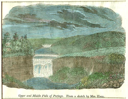
Mrs. Hall made this sketch from what would later be called "Inspiration Point" . The Middle Falls is clearly visible near the center, but includes a smaller cascade just above it. This is likely to be the manmade dam built to power the sawmills and provide adequate depth for a raft which ferried travelers across the River. The Upper Falls appears in the distance and has a peculiar shape. There is no Portage Bridge - that was still a decade away. Construction on the Genesee Valley Canal has not yet reached the eastern bank (left). One can catch a glimpse of Erickson's Brook (Dehgayasoh Creek) along the western bank (right). |
|
In addition, Jim also sent us some interesting comment which he has given us permission to share. What can we glean and conclude from the drawing and from Mr. Hall's statements in the report?
Again, we thank Jim Pomeroy for his submission of material and an excellent historic reference in the 1843 report on the Geology of New York, Part IV which gives us more early information on the formation of the gorge with its falls. This also adds another important figure in the person of James Hall to our list of people that are of importance to the Letchworth story. Mr Hall's work was recognized in the form of a plaque that once was mounted on the rock surface near the top of Eagle Hill that illustrates the rock strata of the gorge. A replica of that original plaque was on display in the park museum for several years. |